The Solution
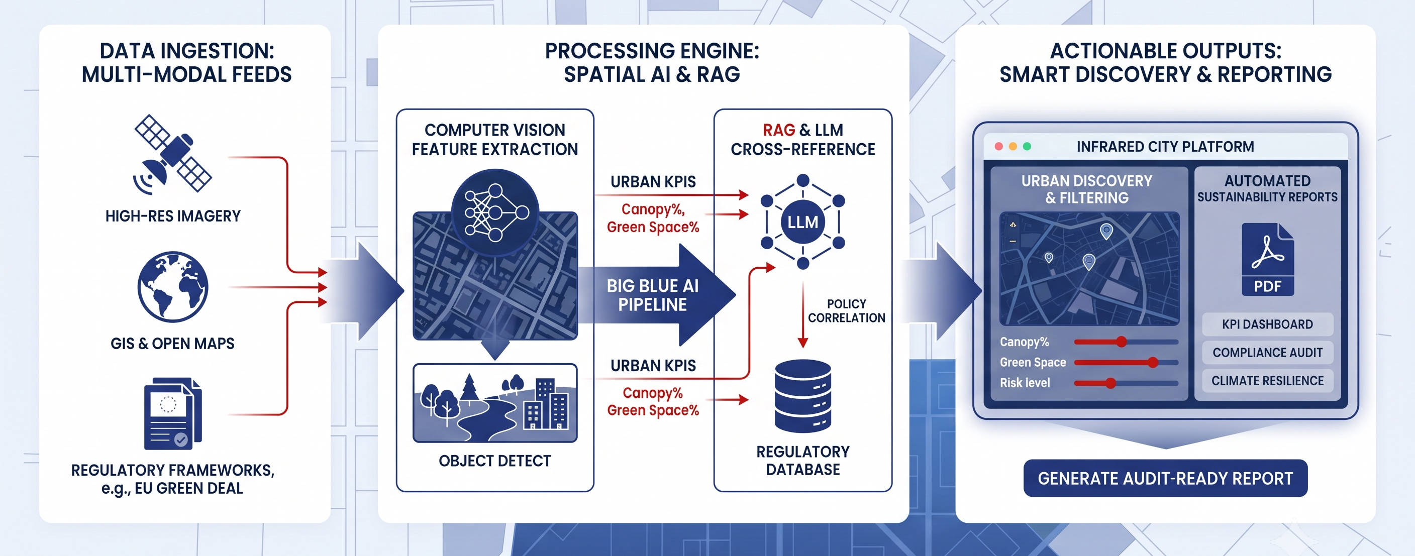
Big Blue AI developed an AI-powered sustainability reporting interface integrated into the Infrared City platform, delivering an automated solution that converts complex spatial data and environmental regulations into clear, actionable climate-resilience insights for urban planning.
- All-in-One Environmental Data Hub: A unified interface that automatically aggregates open GIS mapping, satellite imagery, and environmental regulatory frameworks into a single point of truth.
- Automated Climate Resilience Analytics: An intelligent analysis engine that automatically detects urban elements, such as green space coverage, tree canopy density, and water bodies, and translates them into standardized sustainability KPIs.
- Instant Regulatory Compliance Reporting: A smart document generation system that cross-references spatial location data with environmental laws to produce audit-ready, fully tailored sustainability reports in real time.
- Interactive Urban Discovery & Filtering: A user-friendly spatial exploration tool allowing urban planners to search, filter, and evaluate localized geographic areas for climate risk and environmental impact.
The Challenge
Infrared City recognized that urban developers, municipalities, and sustainability managers face immense friction when attempting to compile environmental and climate-resilience reports. Traditional sustainability reporting is a heavily manual, labor-intensive, and time-consuming process that requires cross-referencing vast, disconnected spatial datasets with rapidly changing climate regulations like the EU Green Deal. To enhance Infrared City's offerings, the operational challenge was to build an automated way to digest raw satellite imagery, map environmental assets, and correlate them with regulatory requirements, enabling urban planning teams to make timely, data-backed decisions.
The Impact
The integration of this spatial AI interface into the infrared.city preview platform delivered transformative capabilities to urban design and environmental compliance workflows:
- End-to-End Report Automation: Slashed the administrative overhead and manual research hours traditionally required by Infrared City clients to aggregate spatial data and draft climate-resilience disclosures.
- Objective Climate Resilience KPIs: Standardized the measurement of urban environmental assets across Infrared City projects by automatically converting high-resolution satellite signals into actionable sustainability metrics.
- Instant Regulatory Alignment: Streamlined compliance with complex policies like the EU Green Deal by anchoring LLM-generated reports directly to validated GIS data points via RAG architecture.
- Data-Driven Urban Planning: Empowered Infrared City stakeholders to assess environmental impacts in real time, fostering higher transparency and faster decision-making for sustainable municipal projects.
How Big Blue AI helped
Big Blue AI bridged the gap between raw spatial data science and real-world urban planning applications. Our engineering team took end-to-end ownership of the complex AI and data pipeline architecture, guiding the project through data API integration, computer vision feature extraction, and LLM/RAG model orchestration. By combining geospatial engineering with state-of-the-art language and vision models, we successfully transformed fragmented satellite telemetry and regulatory text into an intuitive, automated intelligence tool. This close, hands-on collaboration equipped Infrared City GmbH with an innovative, highly scalable feature set ready to redefine digital urban sustainability reporting.